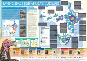
New A1 poster of African vulture strongholds available
Download for your own printing
Download for professional printing (includes crop marks)
citation: Buij, R., Davies, R., Kendall, C., Monadjem, A., with Rahman, L. & Luddington, L. In Prep. Vulture strongholds and key threats: a mapping exercise to guide vulture conservation in Africa.
coordination: Ralph Buij (Wageningen University & Research), Corinne Kendall (North Carolina Zoo), Ara Monadjem (University of Swaziland).
data collation: Lutfor Rahman & Lou Luddington (Habitat Info).
analysis & map production: Rob Davies (Habitat Info).
finance: The vulture surveys, data gathering and habitat and threat modeling were funded by the Dutch Ministry of Economic Affairs, WWF-Netherlands, UNEP-CMS Raptors MoU, North Carolina Zoo, Quagga Foundation, Stichting Vogelpark Avifauna, Stichting Koninklijke Rotterdamse Diergaarde, Detroit Zoological Society, and Stichting Wildlife. We greatly acknowledge their financial support.
data contributors: African Raptor Databank (ARDB) observers, Keith Bildstein, Claire Bracebridge, Evan Buechley, Andre Botha, Ralph Buij, Mike Cadman, Maria Diekmann, Nina Farwig, Toby Galligan, Beckie Garbett, Roi Harel, Ohad Hatzofe, Constant Hoogstad, Gregory Kaltenecker, Adam Kane, Chris Kelly, Corinne Kendall, Glyn Maude, John Mendelsohn, Mike McGrady, Ara Monadjem, Campbell Murn, Ran Nathan, Stoyan Nikolov, Darcy Ogada, Steffen Oppel, Louis Phipps, Sascha Rösner, Lizanne Roxburgh, Andrea Santangeli, Dana Schabo, Orr Spiegel, Munir Virani, and Kerri Wolter (Vulpro); and by the following organisations: IUCN SSC AFRICAN ELEPHANT SPECIALIST GROUP (African Elephant Database), AFRICAN RAPTOR DATABANK, BIRDLIFE INTERNATIONAL & NATURESERVE, BOISE STATE UNIVERSITY, CITES (Monitoring the Illegal Killing of Elephants Database), ENDANGERED WILDLIFE TRUST, HAWK CONSERVANCY TRUST, HAWK MOUNTAIN SANCTUARY, IUCN, MOVEBANK, NORTH CAROLINA ZOO, RAPTORS BOTSWANA, RARE AND ENDANGERED SPECIES TRUST, ROYAL SOCIETY FOR THE PROTECTION OF BIRDS, THE PEREGRINE FUND, UNIVERSITY OF UTAH, VULPRO, WILDLIFE ACT, WILDLIFE CONSERVATION SOCIETY.
range maps
Range maps for 10 African vulture species, provided and updated by the African Raptor Databank for this project.
map R1: Bearded Vulture SMALL_jpeg LARGE_pdf
map R2: White-backed Vulture SMALL_jpeg LARGE_pdf
map R3: Rueppell’s Vulture SMALL_jpeg LARGE_pdf
map R4: Cape Vulture SMALL_jpeg LARGE_pdf
map R5: Griffon Vulture SMALL_jpeg LARGE_pdf
map R6: White-headed Vulture SMALL_jpeg LARGE_pdf
map R7: Lappet-faced Vulture SMALL_jpeg LARGE_pdf
map R8: Cinereous Vulture SMALL_jpeg LARGE_pdf
map R9: Hooded Vulture SMALL_jpeg LARGE_pdf
map R10: Egyptian Vulture SMALL_jpeg LARGE_pdf
map R11: African vulture species richness from rangemap overlays SMALL_jpeg LARGE_pdf
movement analysis maps
A selection of nine maps depicting tracking data and movement areas for vultures across Africa. In total 228 birds tracked.
map M1: movement data for all tracked vultures SMALL_jpeg LARGE_pdf
map M2: movement data: White-backed Vulture SMALL_jpeg LARGE_pdf
map M3: movement data: Rueppell’s Vulture SMALL_jpeg LARGE_pdf
map M4: movement data: Cape Vulture SMALL_jpeg LARGE_pdf
map M5: movement data: Griffon Vulture SMALL_jpeg LARGE_pdf
map M6: movement data: White-headed Vulture SMALL_jpeg LARGE_pdf
map M7: movement data: Lappet-faced Vulture SMALL_jpeg LARGE_pdf
map M9: movement data: Hooded Vulture SMALL_jpeg LARGE_pdf
map M10: movement data: Egyptian Vulture SMALL_jpeg LARGE_pdf
habitat stronghold analysis maps
A selection of nine maps which represent important habitat and movement areas for vultures across Africa.
map S1: current strongholds from habitat models SMALL_jpeg LARGE_pdf
map S2: current strongholds from observation data SMALL_jpeg LARGE_pdf
map S3: current strongholds from all lines of evidence SMALL_jpeg LARGE_pdf
map S4: loss of suitable habitat SMALL_jpeg LARGE_pdf
map S5: overview of strongholds East Africa SMALL_jpeg LARGE_pdf
map S6: overview of strongholds West Africa SMALL_jpeg LARGE_pdf
map S7: overview of strongholds southern Africa SMALL_jpeg LARGE_pdf
map S8: overview of strongholds Africa SMALL_jpeg LARGE_pdf
map S9: African vulture coincidence of occurrence from habitat models SMALL_jpeg LARGE_pdf
threat analysis maps
A selection of thirteen maps which represent known threats to vultures across Africa.
map T1: threat map: exposure to people SMALL_jpeg LARGE_pdf
map T2: threat map: expected development SMALL_jpeg LARGE_pdf
map T3: threat map: electrocution SMALL_jpeg LARGE_pdf
map T4: threat map: wind turbine collision risk SMALL_jpeg LARGE_pdf
map T5: threat map: potential future hazards SMALL_jpeg LARGE_pdf
map T6: threat map: traditional medecine market demand SMALL_jpeg LARGE_pdf
map T7: threat map: unintentional poisoning SMALL_jpeg LARGE_pdf
map T8: threat map: intentional poisoning SMALL_jpeg LARGE_pdf
map T9: combined poisoning threat map SMALL_jpeg LARGE_pdf
map T10: density of poisoning incidents SMALL_jpeg LARGE_pdf
map T11: poisoning likelihood SMALL_jpeg LARGE_pdf
map T12: poisoning incidence over time SMALL_jpeg LARGE_pdf
map T13: poisoning mortalities over time SMALL_jpeg LARGE_pdf


