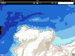

Mobile mapping on the Apple iPad
View the SeaTrust in the Field video produced by habitat INFO demonstrating SeaTrust’s use of mobile GIS solutions either below or by clicking here
Mobile GIS allows companies to collect data rapidly, globally and accurately. It can lead to the development of large spatial databases very quickly with data that can be used going forward for further analysis.
habitat INFO has a wealth of experience in developing mobile GIS solutions for clients all around the World. We use ESRI solutions to bring spatial data to the mobile community for both data viewing and data collection purposes. We have experience with Android, iOS and Windows platforms and a variety of different devices. The solutions we provide are simple but very effective allowing users from all backgrounds, including those without any prior GIS experience, to easily collect and manage data.
Projects to date have included:
- Cetacean monitoring
- Dragonfly recording
- African Raptors
To go alongside mobile GIS developments we often find clients look towards a web mapping solution to facilitate the sharing, editing and management of data in a desktop environment. This is something we’d be happy to talk through with you and help you understand the benefits of.
Contact us to find out more about how our mobile GIS solutions can help you collect data or add value to processes you already have in place.

