The objective of our risk and vulnerability analysis is to identify where people may be expected to be most vulnerable to all of the major expected difficulties associated with climate change, notably food security, water shortages, disasters and associated health problems.
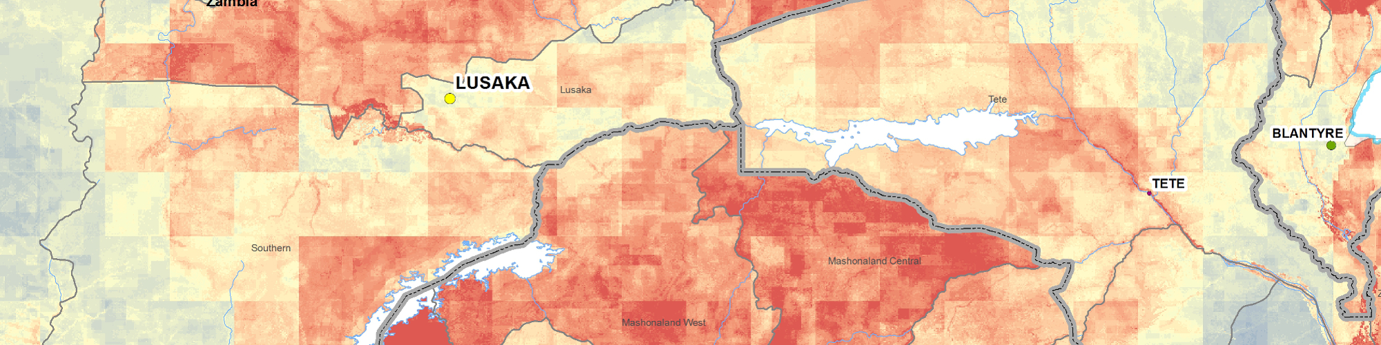
Our aim is to develop a composite index of vulnerability. This is done by combining the influence of different data layers into one final summary layer (hotspots). The advantage of this approach is it presents an immediately accessible graphic representation of the expected distribution of the problem. This is favoured by politicians and decision makers because it is expedient. Throughout the projects we’ve been involved with the summary maps have proved very useful because they either help promote consensus or they provide the start point for discussion and validation to begin.
habitat INFO’s approach to risk and vulnerability takes a three stage approach:
- 1st we look at the potential climate hazards that exist and pose a threat to communities. We refer to this as exposure. We access relevant climate data for both the current and future (2050) time frames. This data pertains to topics such as seasonality, length of the growing period and projected changes in precipitation and temperature.
- We then look at the sensitivity of communities by factoring in data such as soil sensitivity, rainfall per capita, dietary information, water stress etc. We pay particular attention to per capita resources both now and into the future with the acknowledgement that in the future population pressure is likely to play just as big a role in risk and vulnerability as the changing climate.
- Finally we assess the population’s ability to adapt to climate change. This we refer to as adaptive capacity. In order to do this we look at several demographic datasets such as gender equality, education, wealth and employment. We also factor in datasets relating to health and access to healthcare, infrastructure and travel times and those relevant to agriculture such as irrigation potential.
We ensure the scale of the data sets is standardized and then, for each summary layer (exposure, sensitivity and adaptive capacity) we add the input layers together whilst also applying a weighting to them in order to allow those which are more important, have a more robust method or have a high spatial resolution to have more of an impact on the final summary layer. To arrive at the final hotspots map exposure and sensitivity are multiplied together to produce problem areas which is finally divided by adaptive capacity.
We have carried out this work extensively across Africa and as such have developed a large in-house collection of data relevant to this type of mapping. Much of the data we hold extends Worldwide and we are therefore, well suited to carrying out this type of analysis elsewhere in the World too.
Projects to date include:
- Southern African Development Community (SADC) Regional Climate Change Programme (RCCP)
- Zambezi basin risk and vulnerability mapping
- Limpopo basin risk and vulnerability mapping
- Mozambique risk and vulnerability mapping
- Horn of Africa resilience mapping
More information about the methodology is available in the following presentations which were presented at the Botswana climate change workshop, Maun, April 2014: